Navigation
Méditerranée

Navigation
Diaporama

Navigation


Les Calanques-Cruise
The Provencal Fjords The Norwegian Abers The Brittany Calanques All of those expressions could be used, were it not for the risk of appearing a bit “fada”, as people say round here. These calanques, which elsewhere in the world might have been called Rias, are deep valleys formed by rivers or glaciers while the sea level was at its lowest, and subsequently submerged during the geological flood tide. Guided tour of the Calanques
Let’s start with a riddle: Why is the water in the coves always colder than elsewhere? It’s because underwater springs in the depths of the calanques are fed with abundant supplies of water via the karstic tunnel network of faults and fissures originating in the rocky inland hills of Provence. These springs are the invisible ghosts of the swelling ancient rivers that hollowed out the calanques until the sea invaded around 10,000 years ago.
Kept cool in the depths of the earth for weeks, months, or often much longer periods, this fresh water comes up from underground lakes at a temperature more suitable for a nice chilled pastis than for swimming.
Another question: Do you know why the sea bed in the coves is turquoise in some places and deep navy blue in others? It all depends on whether there are Posidonia beds or not. Posidonia oceanica is not seaweed but sea grass. It is said by some that these meadows were once pastures for the local bison, at the time when people still lived in the Cosquer cave, discovered at the foot of a cliff face between Morgiou and Sormiou.
These deep rooted plants form a mat resistant to the erosion of the sandy sea bed. They act as grazing grounds for herbivorous fish, shelter for baby fish and smaller species, and a habitat for hundreds of species of marine animals. When uprooted, the meadows take years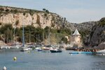 to grow back. Their worst enemy is the chafing of a boat chain and anchor.
So if you enjoy the beautiful blue waters of the calanques, make sure you drop anchor where the water is turquoise. Do your bit to protect the sea grass meadows.
This said, let’s begin our cruise. We’ve just left Port Miou, the only cove in the bay of Cassis, and we are making our way to Marseilles.
PORT PIN AND EN VAU
Exposed to southerly and easterly winds, the twin coves of Ports Pin and En Vau form a “Y” shape between the Cacau headland (extremity of the bay of Cassis) and the commanding Castel Vieil headland. In an area where the sea wind can rise, anchorage in Port Pin is to be preferred although the cove is aesthetically less stunning than its neighbour. Once tendered though, you have easy access to the water’s edge and can take a walk through the superb pine forest. Port Pin (pine tree port) is well named.
En Vau (the Vale) is the more striking of the two. The cove is narrow and deep. You will not be able to let out the chain cable to any length except at the end of the calanque, where it is better to leave the swimmers in peace. If you want to drop anchor among the rocks, an additional stern mooring is highly recommended. En Vau really is a canyon. It is easy to see that there was once a powerful, gushing stream here. It is as if the “Gorges de Verdon” were to be drowned out by the sea in 2367 AD!
When exiting En Vau, the view of Castel Vieil headland is spectacular. The varying sized hollows, which appear as smooth as silk, provide nesting places for the hundreds of birds.
OULE and ESSAÏDON
You will understand by the name Oule, which means “cauldron”, why one should not enter, unless the sea is completely calm. As soon as any wind rises it becomes infernal. Notice the spectacular jagged pinnacles, like the lacerating jawbone of a crocodile ready to snap up any vessel in one bite! In spite of this, it is a place of exceptional beauty and unique geometry in the calanques, where the limestone columns are likened to organ pipes.
Essaïdon follows immediately after and is also an inappropriate mooring. Here, daylight streams through the needle-like pinnacles at sea level. When passing by, you’ll understand why this cove is named after a farming implement. It is a beautiful spot, and in good weather you can sail close to the shore, and enjoy exceptional sea diving.
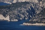
DEVENSON, ŒIL DE VERRE, PIERRE TOMBÉE
This spot is less of a cove, more like a sheer cliff. On this site the 250m high vertical and compact cliff face, provide renowned rock-climbing routes. It is spectacularly beautiful but not very welcoming when seeking a mooring.
Further on, having passed Cap Devenson and Anse des Enfers, we get to the Œil de Verre cove, named after a block of quartz. (Can you find it?) At last we discover the easily recognisable “Pierre Tombée” (fallen rock). Thereafter we reach the coves where mooring in the port becomes possible.
SUGITON
Sugiton is an awesome circus with spectacular lofty cliff faces, overlooking an embankment populated by pine trees sporadically interspersed by scrub. Below, you have a small crystal-watered cove, nestling between white rocks and a minuscule beach, with an Aleppo pine tree leaning over elegantly to provide shade for swimmers. It is better not have a boat of more than eight metres if you want to cast anchor. Otherwise you’ll need to remain outside the cove, exposed to the winds. In any case the Sugiton cove offers no sanctuary; the Morgiou headline provides the only shelter and is at such distance that it only agitates the swell.
At the entrance, the rock is called “the torpedo boat”. If you think you know why, answers on a postcard. Another prominent underwater spring can be found here.
MORGIOU
Morgiou is one of the best known of Marseilles’ callanques, and is inhabited all year round. Since ships were first made, this has been a well appreciated shelter for sailors, who sometimes found themselves too far from their home port of Marseilles or Cassis, when surprised by unexpected gusts of winds. While wonderfully protected from the Mistral and other inland winds, it is unprotected from the easterly and south-easterly gusts.
Napoleon constructed an advanced military battery position on the promontory, to stop enemy vessels mooring in the cove. Hidden from sight they could have plotted skulduggery against Marseilles.
At the heart of the cove, old fishing shacks have been turned into villas benefiting from an exclusive setting and the little stone block port which breaks the easterly swell.
This cove is a magnificent port of call, with wide access, easy for manoeuvres. The beauty of the rocks, the diverse vegetation and the bird-life catch one’s eye as much as the local residents’ lifestyle.
SORMIOU
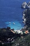
Unless you have a very calm day and a very small boat, this is the last possible port of call en route for Marseilles. The calanque of Sormiou is popular with the people of Marseilles. While road access down to the seafront makes it very convenient, the limited number of habitations means its awe-inspiring surroundings remain relatively untouched. Sormiou provides good shelter from the Mistral, but like Morgiou is unsatisfactory or even unsafe when the south-westerly sea wind blows.
Again, be careful to drop anchor in the turquoise waters. Alas! They are very large areas, and the remainder, where there are sea grass meadows, is much smaller, but abundant marine life in the shallow waters can be observed with mask and fins.
In summertime, this cove is crowded with boats. We can only wonder when the authorities will install ecological mooring buoys to stop the boats ploughing up what remains of the meadows. Of course there will be a cost, but there is also an ecological cost to our thoughtless behaviour.
The sea is a place of freedom - but we should use our freedom to preserve, not destroy.
CALLELONGUE
Callelongue as port of call can really only be mentioned in passing. It is very narrow, with no free berths or anchorage. Behind the Isle of Maïre, at the foot of Marseillevevre signal station, this channel takes the form of a sock, and displays a fanfare of colours. After this long thin cove, head through the “Baie des Singes” (monkey bay) strait. Its restaurant can be reached on foot. Take care. The depth of the sea bed rises to 2.5m. Keep a close eye on your nautical chart and depth sounder.
You are now in the bay of Marseilles, and another adventure is just beginning!

