Navigation
Méditerranée

Navigation
Diaporama

Navigation


Saint Cyprien-The town claimed back from the marshes
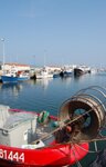
The port of Saint Cyprien is proud of its 2,200 moorings, its marinas and the areas reclaimed from the marshes, but is well aware that it is built on sand and silt. Throughout the times of the Romans, Charlemagne, the Knights Templar and the last Kings of France, the history of this region has been a perpetual struggle against the effects of both silt and mud, and the approach of the sea.
 In the 10th century, what is now Saint Cyprien was a former Roman house: Villa Sallix, later called Villa Saulx, and then Villa de la Saussaie. The village began to develop around 915, with the accession of Charlemagne, the establishment of the feudal system and the proliferation of churches under the influence of the Carolingians. The place was dedicated to the Christian martyr Saint Cyprien (200-258) a bishop who was decapitated in Carthage for inciting disorder. This name Saint Cyprien persisted through the centuries unlike other villages whose names changed.
 But although the name did not change, the lie of the land certainly did! Saint Cyprien's destiny has been linked to the movement of the sea, to the uncertainty of the coastal features and to the salt marshes that occupied that indistinct area between water and dry land.
The history of Saint Cyprien is closely involved with that of a little town 5 km inland, called Elne, which at the time was called Illibéris from the Celtic Illimberi meaning "hill in the middle of the silt". The funny thing is, to this day the inhabitants of Elne are still called Illibériens!
In those days, the sea reached the ramparts of Elne but it was not deep enough for boats to sail there. They dredged a channel which became the Elne canal and thus Saint Cyprien became the port for Illibéris. Farmers and fishermen settled there and cultivated the surrounding land, taking advantage of the trade between the two little towns, the fish that came up the channel and that famous silt.
 Decontamination of the marshes became standard practice with the arrival of the Templars who had a lot of influence in the area from the 12th century. The first advisor to the main Templar Commandery in the area was called Arnaud de Saint Cyprien. The Templars of Mas Deu were dominant in the Southern plain, and they drained the majority of the marshes from Salses to Argelès. Their aim was to finance the Crusades to the East. They grew grapes and cereals, and built factories, tanneries and workshops for leather goods and they also raised cattle. In this way, they helped the inhabitants of the region to farm the newly-reclaimed land and significantly improve their living conditions. Throughout the Middle Ages, decontamination continued with the construction of a network of aqueducts and canals. In the 13th century a church was built and by about 1385 the town boasted a population of 350.
Saint Cyprien took a second "great leap forward" in the mid 18th century through sea-trade in cod, oil, and, from Mont Canigou, coal and iron. Relations between Elne and Saint Cyprien were re-established, and along the coastline, which was not yet as it appears today, two little fishermen's villages were established. This was a precursor of what was to happen much later when, after the destruction of the second World War, the time came for rebuilding.
At the end of the 1940s, the Ministry for Reconstruction quickly built housing estates to rehouse families. This sowed the seeds for the idea of creating a sea-village. Then, in 1962, arrangements had to be made for new groups of people arriving from Algeria. This gave rise to an immense development programme for the commune. The objective was to transform those areas that had formerly been unusable, just as the Carolingians and the Templars had done in the past.
 But this time, it involved creating a modern seaside resort, intended to be one of the most attractive on the coast. There was a great deal of work to be done. It was not until 1967 that the dual-purpose port was created. As well as the traditional facilities for pleasure boats, the intention was to create marinas which was a relatively novel idea at the time. The gamble has paid off. Today, this port with 2,200 moorings, ranks second in the Mediterranean Basin and third in the whole of France. But man is well aware that there is no end to the battle with the sea as it rises and falls.…